

Map 2026
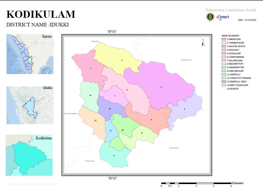
Geography This document is the final order issued by the Kerala State Delimitation Commission on 15 May 2025. Through this, the Kodikkulam Grama Panchayat in Idukki district has been divided into 14 electoral wards (constituencies) and the boundaries and population of each ward have been finally determined.
Key features of the report
Number of wards
The number of members to be elected through direct elections in Kodikkulam Grama Panchayat has been fixed at 14.
On the basis of that, the Panchayat has been divided into 14 wards.
Delimitation process
The draft ward division proposals were published on 18.11.2024.
Complaints and comments were received from the public.
The final order was issued after examining the complaints received and holding hearings.
Names of Wards
The 14 wards in the panchayat are:
Parapuzha
Thennathoor
Kaliyar Estate
Koduveli
Kodikulam
Cheriyampara
Vellamchira
Nedumattom
Vandamattom
Anjakulam
Airampilly
Cheruthottinkara
Airampilly West
West Kodikulam
Demographic Analysis
Ward with the highest population: Kodikulam (1,010 people), Vellamchira (1,010 people).
Ward with the lowest population: Anjakulam (853 people).
The population of the wards is approximately 850 to 1,010. This shows an effort to ensure demographic balance.
Delimitation
The boundaries of the wards have been determined based on roads, rivers, streams, estate boundaries and the boundaries of neighboring panchayats.
This has ensured a clear geographical and administrative division of the wards.
Administrative Significance
This order is an important step to make the representation of the people in the local self-government bodies more balanced and efficient. Its main objective is to ensure equal political representation for each area by eliminating large differences in the population of the wards. Furthermore, future Gram Panchayat elections will be held on the basis of this ward division.
Conclusion
This order relating to the ward redivision of the Kodikulam Gram Panchayat is the final result of a comprehensive delimitation exercise prepared with the aim of population balance, administrative convenience and equality of representation of the people. This document will serve as a basic document for the future electoral arrangements and development plans of the Panchayat.


